![[Ocean Oasis Field Guide]](images/bnr-oo-field.gif)
| |
|
|
|
|
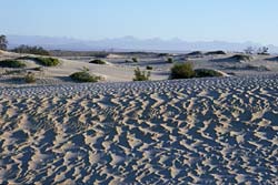
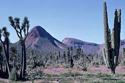
The name Vizcaíno Desert was originally applied to the roughly triangular desert on the west coast of the central Baja California peninsula, just south of Vizcaíno Bay. In more recent times, the name has come to designate a much larger area, the subdivision of the Sonoran Desert which extends from north of El Rosario, southward inland to the Magdalena Plain and along the coast to Barra San Juan. It reaches eastward in the central part of its range to include mountain areas such as Cerro Matomí, Sierra San Luis, Sierra San Borja, Volcán Las Tres Vírgenes, and Sierra San Francisco. Climate and Geography The rainfall in this central region of the peninsula is highly variable from year to year, because it falls between the two main weather patterns that supply the peninsula with rain. The winter rains that travel down the coast from the northern Pacific—supporting the chaparral vegetation of the northwestern part of the peninsula—rarely reach this far. Likewise, the summer monsoons from the south, which supply the Cape Region's tropical vegetation, are uncertain to reach the central part of the peninsula. The average rainfall in the Vizcaíno Desert is 5 cm (2 in) per year. However, the Vizcaino Desert has another source of precipitation. The Pacific ocean's cool California Current causes frequent coastal fog that can penetrate into the inland areas several kilometers. Condensed fog drips and soaks into the soil, and also supports epiphyptic lichens and plants that can be seen clinging to cacti, fenceposts, and even power lines. Much of the western Vizcaíno is affected by strong winds from the Pacific Ocean, which have produced vast areas of dunes along the coastal Pacific shores of the Vizcaíno (especially around Guerrero Negro). Inland there are water courses flowing from the mountains to the east. Much of the Vizcaíno Desert is covered with rocky sandy soil that has decomposed from granite or basalt. The soils are usually very well drained and neutral to alkaline in pH. Vegetation The same constant buffeting wind causes the plants in the coastal plains to be low, scanty, and widely spaced. Further inland, however, the coastal wind diminishes and the vegetation takes on a more normal height and distribution. North of El Rosario is a 160 km-long transition zone between the Californian Floristic Province and the Vizcaíno Desert subregion. In this zone the vegetation varies from a Mediterranean type climate to a desert climate that exhibits characteristics of both chaparral and desert habitats. South of El Rosario plants such as Aesculus parryi (Parry Buckeye), Bergerocactus emoryi (Velvet Cactus), and other associated Californian plants disappear from the landscape and are replaced by typical Vizcaíno Desert plants. (See list at right.) |
 Vizcaíno Desert in spring bloom in a rainy year—near El Arco.
E. W. Nelson (1922) applied the term Vizcaíno Desert due to the region's close proximity to the adjacent Vizcaíno Bay. The bay was named for Sebastian Vizcaíno, a Spanish explorer who also explored the west coast as far north as the present northern border of California.
Typical Vizcaíno Desert Plants
|
Text by Bob Lauri and Judy Gibson
Photographs by Jon Rebman
Field Guide |
Site Index |
Ocean Oasis Introduction
|
|
© 2000 San Diego Natural History Museum |